Digital Diary
The Landkind Digital Diary is your all-in-one orchard activity log—designed to simplify record-keeping, enhance traceability, and support smarter decision-making.
Key Features:
- Field-Based Recording: Staff can log orchard activities directly from the mobile app by selecting the block or KPIN, choosing from a dropdown of tasks (e.g., girdling, pruning), and adding notes or photos on the spot.
- Calendar View & Export: All entries are time-stamped and synced to a centralized web-based calendar, allowing managers to view, filter, and export data by date, block, or user for easy reporting and analysis.
- Seamless Integration: The diary integrates with Landkind’s orchard map and gate access system, automatically logging staff entry/exit times and safety acknowledgments for full traceability and compliance.
- Management Oversight: Enables real-time visibility of completed tasks, helping managers track progress, compare seasonal activity trends, and ensure nothing gets missed.
Whether you're in the field or at your desk, the Landkind Digital Diary keeps your orchard operations connected, compliant, and under control.
Plant Health.
The plant health workflow in Landkind helps orchard teams quickly identify, record, and respond to plant health issues.
Using a mobile device, users can capture photos, tag GPS locations, and add notes—all synced to a digital orchard map. Categorized issues (e.g., sick plant, needs grafting) can be assigned as tasks, and team members can easily find affected plants using their phones to navigate directly to the exact location.
A pie chart summary on the web app offers a clear visual breakdown of issues, enabling faster decisions and smarter resource allocation.
Tasks
The task workflow in Landkind makes it easy to create, assign, and track orchard jobs.
While out in the orchard, users can quickly capture tasks on the spot by dropping a GPS pin, adding a photo, and writing a note—making it simple to record exactly what’s needed and where. These tasks appear instantly on the orchard map with clear icons and color-coding, so nothing gets forgotten or missed.
Staff and contractors can use their phones—with or without the Landkind app—to navigate directly to the task location, ensuring fast follow-up and clear communication.
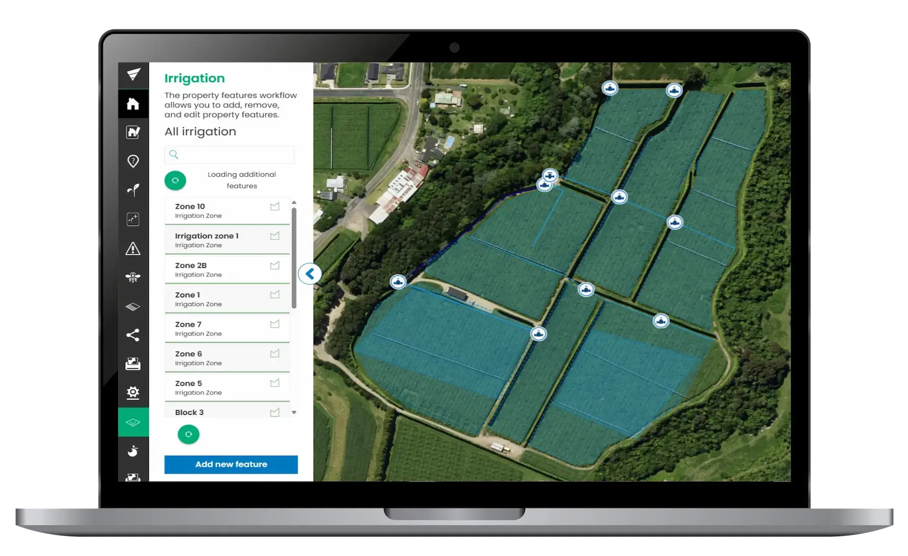
Irrigation.
Landkind’s irrigation workflow gives growers a clear, mapped view of their entire irrigation system.
Pumps, valves, solenoids, and lines can be marked on the orchard map, with photos and notes attached to each.
Using the mobile app, field staff can quickly locate solenoids via GPS and see exactly what blocks or lines they control—making troubleshooting fast and accurate.
Everything is easy to find using the mobile app, a ShareMap, or by printing a physical copy of your map with all irrigation features.
Whether you're fixing a fault, planning upgrades, or reporting for compliance, Landkind keeps irrigation management simple, connected, and reliable.
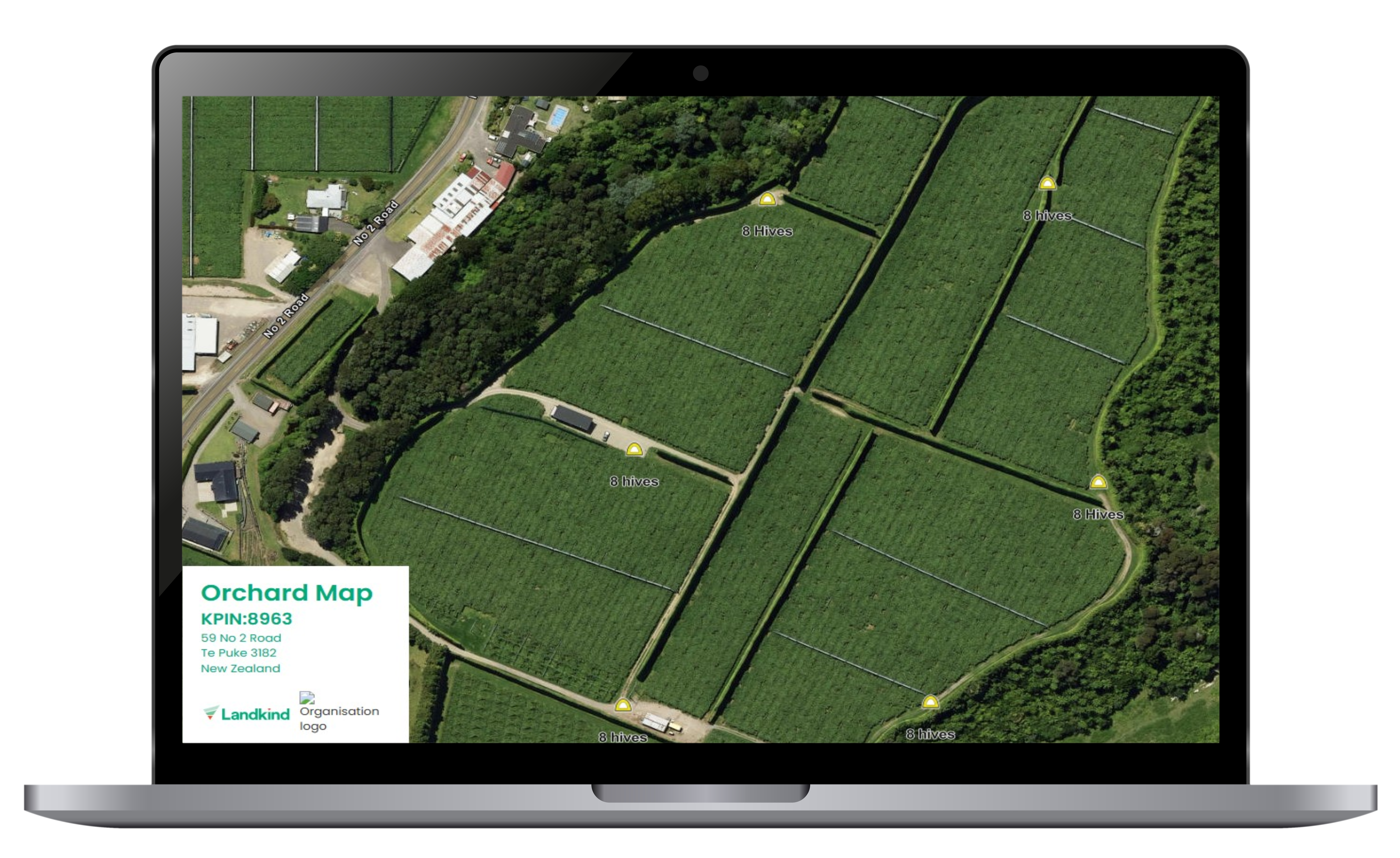
Bee map.
Landkind’s Bees function makes it easy for growers to manage pollination across the orchard.
You can map exactly where hives are to be placed, keep a history of placements, and share hive maps with beekeepers, staff, or contractors. This helps ensure hives are in the right place at the right time, protecting pollination zones and improving results.
You can also view hive locations alongside orchard blocks to check coverage, spot any gaps, and plan better for future seasons.
With mobile access and live updates, Landkind turns hive records into useful insights that support stronger pollination and better yields.
Mobile Explorer.
Landkind’s Map Explorer gives growers a clear, real-time view of everything happening across their orchard.
Easily switch between layers for irrigation, plant health, tasks, hazards, blocks, and more—all from your phone on orchard.
Use the map to see what’s happening, where it’s happening, and navigate straight to the right location using GPS.
You can filter information, zoom into specific areas, and overlay different data sets to get a complete picture of your operation.
The Landkind Map Explorer makes it easy to stay on top of day-to-day work, respond quickly to issues, and keep everyone aligned with what’s happening on orchard.
.png?width=800&height=432&name=New%20App%20-%20Map%20Toggle%20(1).png)
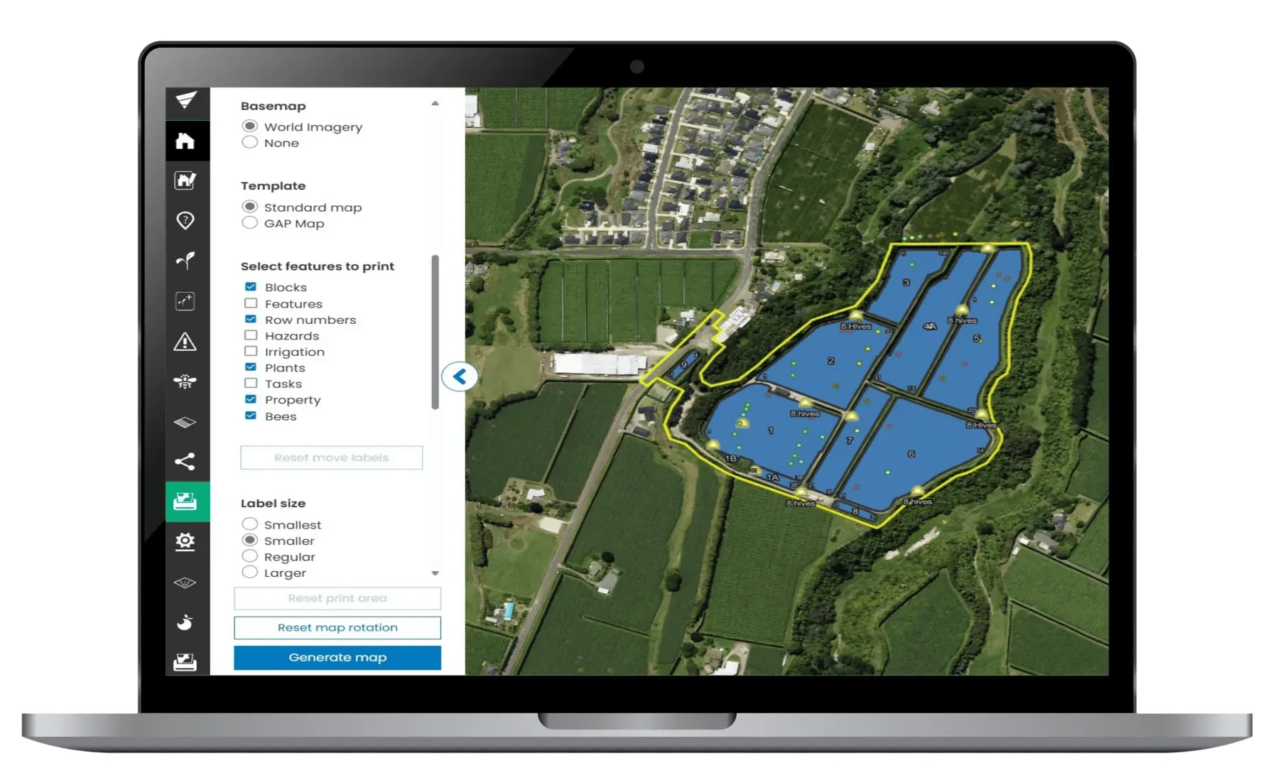
Printed Maps
Landkind makes it simple to create clear, customised printed maps of your orchard.
In just a few clicks, you can select the layers you need—like irrigation, hazards, tasks, or block data—and generate a map that's ready to print.
For compliance, Landkind lets you generate a GAP map that automatically includes all required features to meet Zespri and GLOBAL G.A.P. standards.
Whether you're working offline, preparing for an audit, or briefing your team, Landkind’s print tools give you accurate, up-to-date maps that can be saved digitally or printed as physical copies for use in the field, the office, or during inspections.
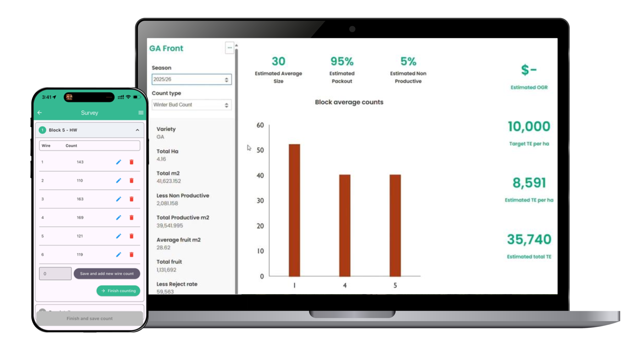
Counting Tool and Crop Estimates
Unlock the power of precision with Landkind’s Digital Crop Counting and Crop Estimate tool—designed to streamline orchard management and forecasting. Whether you're in the field or at your desk, our intuitive platform lets you capture, visualise, and analyse crop data in real time.
Key Features:
- Real-Time Data Capture: Record bud, flower, fruitlet, fruit, and pre/post-thin counts directly in the orchard via mobile or from the office using the Landkind web app.
- Automated Crop Estimates: Instantly extrapolate count data using your own forecasting metrics to generate accurate yield predictions.
- Geo-Spatial Insights: Visualize fruit density and compare seasonal trends using Landkind’s advanced mapping and density calculator.
- Seamless Integration: Syncs with your orchard map, enabling task tracking, irrigation planning, and hazard logging—all in one place.
Capture and use data on your orchard:
• Record data directly in the field using mobile devices.
• Tag photos, notes, and tasks to specific locations on your map.
• Log spray, fertigation, and pruning activities with timestamps.
• Monitor plant health with geo-tagged recording.
• Use GPS to track staff movements and task completion.
• Sync data automatically to the cloud for team-wide access.
• Generate reports for compliance, audits, and planning.
• Centralised data: all orchard information data is in the same place to be retrieved easily and provide staff awareness.
How will the Dynamic Orchard Map benefit you?
• Improved decision-making with real-time, location-based data.
• Reduced paperwork through digital recordkeeping.
• Better traceability for compliance and food safety.
• Optimised labour and input use through targeted actions.
• Enhanced collaboration with shared access across teams.
• Historical insights to guide future orchard planning.
• Increased productivity by reducing time spent on administration.
• GAP compliance - produce your GAP map with a push of a button.
• Estimation map production: You can easily produce your own estimation maps using simple GIS tools.